- Home
- About
- Stakeholders
- Projects
- Water
- Evaluating reservoir operations and the impacts of climate change in the Connecticut River Basin
- Collaborative development of climate information for the Connecticut River Basin using Shared Vision Forecasting
- Impacts of climate change on the Massachusetts Water Resources Authority water supply system
- Climate information for water harvesting and re-use strategies in urban settings
- Delaware River streamflow reconstruction using tree rings
- Coasts
- Health
- Cross-cutting theme: Climate
- Cross-cutting theme: Vulnerability/Evaluation
- Water
- Library
- Resources
- Seminars
- Contact Us

The Urban Northeast
The Urban Northeast corridor, a mega-region spanning Boston to Philadelphia, covers a mere two percent of the nation’s total land area, yet it is home to around 49 million citizens, the largest population cluster in the country and one of the largest in the world. This densely populated, interconnected area contains the nation’s largest agglomeration of economic activity and urbanized land, generating twenty percent of the country’s gross domestic product (GDP). Despite the geographic and cultural diversity that gives each city its own character, these shared economic and demographic qualities make this coastal mega-region’s natural and societal landscape more vulnerable to the impacts of climate change and weather-related events as a whole.
The area’s climate is temperate and cooling sea breezes occur along the coast. The region has been warming over the last 100 years, and climate change is expected to bring further changes over the next century. In addition to climate change, the urban heat island effect causes cities in the region to be warmer than surrounding areas due to the absorption of sunlight by buildings and pavements during the day and reradiation as heat at night.
A broad set of potential climate change impacts have been identified, including shifts in regional water supplies, increased energy demand, greater public health threats, enhanced probability of flooding, and ecological changes. Potential climate impacts on coastal communities are highlighted here because the region’s most inhabited areas lie either on or near the coast, and so these communities will be more negatively affected by climate change. Specific changes include increased risk of coastal flooding and greater exposure of residents, their property, coastal wetlands, and tidal marshes to inundation from sea level rise. The effects and costs of potentially hazardous flooding events would greatly impair the continual growth of coastal communities, environments, and transportation infrastructure in these northeast cities.
Please click on the questions below to expand and collapse their answers.
What changes have been projected for the region?
Since the early twentieth century, a warming trend has been observed in the Northeast mega-region. A 0.5°F increase in temperature has been observed every ten years since 1970. Global climate models (GCMs) project that the rate and amount of warming, as well as the frequency and severity of extreme events such as heat waves and droughts, will increase over the twenty-first century. In addition, sea-level rise would lead to more damaging coastal floods, salinization of aquifers, loss of coastal land, and other effects. Under current high emissions conditions, CO2 levels are predicted to rise from around 380 parts per million (ppm) to 940 ppm by the end of the twenty-first century.
Climate
The regional warming trend is greater than the rise of about 0.7°F (~0.4°C) observed for the nation as a whole, and it is also greater than the rise in global near-surface air temperature of about 1.33°F (0.74°C). Precipitation has also increased slightly over the past century with a tendency towards increased extremes. Based on recent climate projections, scientists anticipate temperatures to rise 2.5°to 4°F in winter and 1.5° to 3.5°F in summer across the region over the next thirty years. Starting mid-century, greater climate shifts have been projected if emissions continue to be released into the atmosphere at its current high rate. By 2100, winters in the Northeast could experience up to a 12°F increase in temperature and we may see in summer a 14°F jump. Such increases would forever alter the lengths and intensity of our four seasons. Winter snow could be cut in half and our cities may experience temperatures over 100°F for 20 days per year. Intense warmth during our summers may be extended for three weeks on both ends of the season. The global average sea level has been estimated to rise up to two feet, while droughts could simultaneously occur every summer.
Precipitation
Over the past one hundred years, the Northeast has experience a gradual 5-10% annual increase in precipitation. Usually, the increase occurs during fall, summer, and spring, but in recent decades, the most has fallen in winter, but as rain and not snow. It is predicted that by 2100, an average of 20-30% increase could occur. The intensity of precipitation is also projected to severly increase. Heavy precipitation, defined as more than two inches of rainfall within a 48-hour period, will fall during coastal storms. Large increases in precipitation during these storms can affect water quality, groundwater supply, erosion, and increase the risks of waterborne disease and floods.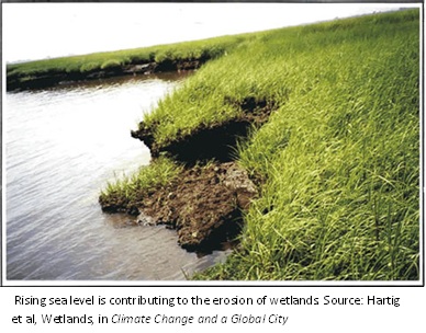
Soil moisture, Evaporation, Runoff, and Drought
Average temperature increases during winter will melt snow faster, increasing soil moisture and runoff. Soon after that in late summer, when temperatures are at their annual highest, that same soil will experience a lack of moisture due to increased evaporation rates. Stream flow and ice cover on freshwater bodies in the region have been visibly affected by warmer temperatures. In simple terms, climate change has extremified stream flow with high winter flows (flooding) and low flows in summer (increasing the chances of drought). The complete thawing of surface ice on these bodies has shifted anywhere from 9 to 16 days earlier than in the past, and the highest stream flow now occurs 7 to 14 days earlier. Stream flow is projected to occur 4 or 5 days earlier within the next few decades, perhaps reaching 10 days early by 2100. Because the overall amount of melted snow will rise, high-flow events are to happen more frequently and in places where they have never occurred before. Additional high-flow events will raise the chances of flooding that could greatly damage our coastal, urban environments.
How will these changes affect the region?
The climate change impacts projected for the urban Northeast corridor will affect infrastructure, coastal communities, water supply, health, energy demand, and the regional economy. These impacts interact in complex and dynamic ways because of the high population density, heterogeneous ecosystems, and extensive built infrastructure in the region.
Infrastructure
Most of the region’s low-elevation infrastructure, including buildings, sewage, bridge and tunnel access roads, subway stations, tunnels, highways, and the region’s airports, will be at increased risk of flooding in coming decades. These important components of the region provide and maintain a large-scale public service. In addition to the risk of storm flooding, some coastal transportation facilities may be at risk of inundation as the sea level rises.
Boston
Boston’s infrastructure was not created with cope with mass coastal flooding. The strength of its coastal defenses, such as seawalls, that protect coastal neighborhoods from waves and flooding would be severely tested under such conditions. Some of the city’s most famous landmarks are located on Boston’s coast. If greenhouse gas emissions are not reduced, newly projected flood zones would inundate a much larger area, putting these historic buildings at risk for destruction. As the city relies on the oldest subway system in the United States, it was not built with significantly higher sea levels and flood risks in mind. Also, tunnel entrances are not flood-proof. One can see climate change impacts underway with the flooding of a subway tunnel entrance in 1996. Damages cost the government over $70 million and weeks of station closure. With regards to sewers and stormwater systems, mass flooding would put its adequacy at risk, potentially backing up and overflowing sewer lines and delaying stormwater drainage.
New York
Four out of five boroughs of New York City are located on islands. The bridges and tunnels that connect the five boroughs are critical bottlenecks along the main transportation paths to the suburbs and counties located in the region. The New York metropolitan region is home to the largest public transportation system in the United States. Many organizations are part of this system: the Metropolitan Transportation Authority (MTA), New Jersey Transit (NJT), and the Port Authority of New York and New Jersey (PANYNJ), to name a few. MTA operates subways, buses, and railroads that move 5.7 million riders a day or 1.7 billion in a year. The MTA’s bridges and tunnels carry upwards of a quarter of a billion vehicles annually, more than any other bridge and tunnel authority in the nation.
Many elements of the transportation and other essential infrastructure systems in the New York metropolitan region are located at elevations two to six feet above current sea level. Storms frequently produce flood waters that exceed six feet. Bridge access roads, entrances to road and rail tunnels, and many transportation facilities are put in jeopardy by flooding, including all three of the major New York metropolitan region airports (La Guardia, JFK, and Newark-Liberty), the Holland Tunnel and Lincoln Tunnel, the Passenger Ship Terminal, and major arteries like the FDR Drive, the Brooklyn Belt Parkway, and the New Jersey Turnpike as it crosses the Hackensack Meadowlands. Projections have been made about the height of future flood waters which indicate that at the least some transportation facilities could be under 6 to 16 feet of water.
Philadelphia
Philadelphia is one of America’s earliest-developed cities, and because of that, its aging skeleton requires constant inspection and upkeep. Some of its water lines date all the way back to 1824. The Water Department takes some of Philadelphia’s water supply from the Delaware River, which would be filled with salt if its water levels were to significantly rise. Currently, the city’s drinking water treatment process is not able to remove salt contents. This event would therefore force Philadelphia to spend millions of dollars entirely re-engineering the water treatment plants.
Coastal communities and environment
Climate change will affect the coastal environments of the urban Northeast corridor through sea-level rise and its associated impacts, including more frequent storms and flooding, higher rates of beach erosion, submergence of coastal wetlands, and saltwater intrusion. These stressors will put some coastal developments at increasing risk of damage. Coastal wetland losses disrupt current habitats of birds, fish, and other wildlife. This is probably related to sea level rise already occurring in the region, as well as to changes in land use, sedimentation, and pollution.
Storm Flooding
Sea-level rise would enlarge the area likely to be inundated by these coastal storms because storm flooding would reach higher inland elevations. Coastal storms striking the region are of two types: [1] extratropical cyclones (“Nor’easters”) and [2] hurricanes. Nor’easters are responsible for major coastal flooding and beach erosion because they cover a larger spatial area than hurricanes and often last longer, so they take place over several tidal cycles at a particular location. Nor’easters are also more common than hurricanes in the urban Northeast corridor, and will become even more frequent with rising sea levels. Since the 1970s, nor’easters have been shifting northward, striking Boston/New England more intensely and frequently than the NY/NJ coast. Although rarer than nor’easters, hurricanes sometimes find their way north during the summer and fall. A general warming of the ocean has been partly linked to the formation and increased frequency of hurricanes. Even if this type of storm remains infrequent in the Northeast, disregard of their possibility when planning and developing coastlines could result in unnecessary damage when they do arrive. Because of the highly developed nature of the coast within the region, a large population and considerable private property and public infrastructure are potentially at risk of hazardous events (i.e. inundation and flooding) associated with sea-level rise. Land below five feet (1.5 meters), such as Coney Island in New York City, could be permanently lost to inundation.Flood risk zones at coastal sites cut across a wide range of income and housing values.
Beach Erosion
Beaches are continually changing as sand is shifted by waves, tides, and currents. Sea-level rise and land subsidence contribute to beach erosion and the narrowing or movement of barrier islands. With climate change, rates of beach erosion would double or triple by the 2020s, increasing three to six times by the 2050s, and four to ten times by the 2080s, relative to the first decade of the twenty-first century. These waves and currents have been gradually reshaping Cape Cod, a large peninsula just south of Boston. Each year, the Cape loses about 33 acres of land to rising seas and erosion caused by storm waves. An increase of storms, like nor’easters, contributes most dramatically to the reshaping of the peninsula.
To compensate for losses from erosion, additional sand would have to be placed on the beaches. Sand replacement, also called beach nourishment, may remain a viable option through mid-century, but could become significantly more costly, particularly for the high-end warming scenarios, by the end of the century.
Wetlands
Wetlands and salt marshes buffer coastal zones from erosion and wave damage. They also provide a habitat for migratory birds, fish, shellfish, and many threatened aquatic species. Sea-level rise poses a significant risk of additional losses to the already threatened coastal wetlands in the region. Studies of selected salt-marsh islands in New York’s Jamaica Bay wetland indicate that they have lost roughly 12% of their total area since 1959, with sea-level rise as a possible causative factor. The coast of the Long Island Sound has already lost about 60% of wetlands to mass development and drainage1. Other threats to coastal wetlands include warmer temperatures and increasing nitrogen and phosphorus input from sewage and runoff from cultivated land. The rate of loss is projected to exceed observed historical rates of salt-marsh accretion and will disrupt current habitats of wildlife. Recreation areas located within wetlands are also threatened by inundation. Projected full inundation of barrier islands would fully expose these coastal salt marshes to storm and wave damage.
Public health
More frequent daily temperatures of over 100°F would augment the risk of heat-related illnesses and fatalities among vulnerable communities, such as children, the disabled and the elderly. The IPCC has recently found that urban areas will feel the impacts of heat waves more intensely due to the higher concentration of vulnerable populations and the urban heat-island effect (explained below). During the summer of 2006, New York City experienced two extreme heat waves where 46 people died, 80% of them over 50 years of age. Between 1993 and 2003, heat was the leading weather-related cause of death for six of the ten years. Heat exposure was the reason for 3,442 fatalities from 1999 to 2003. If the same warming patterns persist, summer heat-related mortality could increase 55% by the 2020s, more than double by the 2050s and more than triple by the 2080s. By the end of the century, the biggest cities in the Northeast region are projected to experience at least an additional 50 days with temperatures over 90°F.
Fluctuations in climate could also contribute indirectly to at least three classes of health problems: incidence of certain vector-borne diseases such as West Nile Virus, Lyme disease, and malaria may rise; water-borne disease organisms may become more prevalent; and photochemical air pollution may increase. Over the next several decades, impacts of climate change on ground-level ozone concentrations are not likely to be a major public health concern, but by the year 2100, pollen-based allergies and asthma-related hospital admissions are expected to worsen. This can be attributed to an earlier and higher pollen-production rate and a general increase in plant growth across the region. Provided that greenhouse gas emissions are not reduced, Philadelphia’s frequent failures to meet federally-instituted air quality standards will quadruple.
Our water supply
Greater climate variability is projected to increase the frequency of droughts and floods, affecting the quality of our regional water supply. Northeast, urban water supply systems should be able to cope with climate variability and change over the next several decades, but there are likely to be significant challenges during the latter part of the century.
Rising sea levels could intensify the migration of saltwater into the region’s urban water supply and coastal aquifers. In Camden, NJ, a severe drought in the 1960s reduced southward flows in the Delaware River enough that saltwater was able to intrude further north and enter the city’s water wells. A similar issue could occur in New York’s Hudson River where the salt front could reach the Chelsea Pump Station for a major portion of the year. The Chelsea Pump Station provides an emergency source of water for New York City during periods of drought. A study of the costs associated with increasing the withdrawal capacity of the Chelsea Pump Station system indicated that withdrawing an additional 100 mgd of water could cost $28 million, and an additional 200 mgd of water would cost $86 million; the costs with filtration would be $223.5 million and $327.9 million. Saltwater may also seep into Long Island aquifers, compromising this critical water supply. Provided that sea levels rise the projected 10 to 23 inches, we must be prepared for more intense saltwater intrusion in our freshwater sources, posing greater health risks to residents and larger expenditures to fix the problem.
Energy demand
Compared to entire countries, the Northeast region alone is already the seventh largest source of greenhouse gas emissions from energy use. A warming climate will raise the overall use of electrical energy because the increase in demand to power summer cooling will outweigh the decrease in power demand for winter warming needs. The electric system will be increasingly stressed during summer heat waves. Recent regional studies have shown that the peak demand on a day with a temperature of 101°F and 80% humidity would be about 40% more than a day that is 85°F with 40% humidity.
The urban heat island effect already causes cities to be warmer than the surrounding countryside. The increase in temperature is caused by the absorption of heat by concrete, brick, and pavement, the exhaust from machinery during the day, and its reradiation at night. A lack of vegetation in the urban environment heightens this process because more absorptive materials lack shade. About 14 million people live in Northeast cities, and as the climate warms, they are less likely to spend time outdoors, greatly increasing the amount of air conditioners needed and used. Under a warming climate, the urban heat island effect will increasingly become an issue of regional concern not only with regards to energy demand, but also with concern to city dwellers’ ability to acclimatize their bodies to warm nighttime temperatures.
Regional economy
Such dramatic changes in climate and average sea level are likely to be costly and would seriously impact the urban corridor’s economic vitality. Cities and their surrounding areas throughout the region are already in the process of rebuilding their aging basic infrastructure at high costs. Sea-level rise and land subsidence are projected to lead to additional infrastructure losses from coastal floods and to accelerate coastal erosion; the costs associated with these losses will weaken an already stressed regional economy.
Projected Damages to Infrastructure
Coastal flooding that currently happens in the region once a century could begin to occur every ten years in New York City and yearly in Boston and Atlantic City, NJ. The expected annual loss from coastal storms exceeds $100 million per year. This loss is small enough to be absorbed by the region’s $1 trillion economy. However, losses do not occur with an annual periodicity. Rather, they occur during infrequent extreme events such as the Nor’easter of 1992. Extreme events have the potential to cause the loss of tens and potentially hundreds of billions of dollars. Such large losses could deprive the economy of a large fraction of the gross regional product and negatively affect insurers, policyholders and the uninsured.
Strategies for coping with coastal erosion and flood damages associated with sea-level rise include defending the shoreline by means of protective structures, beach restoration, and ultimately, retreat. Even at present rates of sea-level rise and land subsidence, most of the shoreline of the New York and Boston metropolitan areas is eroding. In response, existing hard structures – seawalls, groins, jetties, breakwaters – may need to be strengthened and elevated repeatedly and beaches will require additional sand replenishment. The increased costs of retrofitting existing structures or armoring selected portions of the coast may be viable in areas with a high population density or in areas with a high property-value, such as Manhattan, NY, Jersey City/Hoboken, NJ, and Cape Cod, MA. In some locations, affluent shore property owners or seaside communities may also be willing to incur the additional expenses to save their beaches, as for example in Southampton and Easthampton, Long Island. However, other stretches of the coastline may not be able to command the necessary resources.
Projected Damages from Erosion
Over 70% of the world’s sandy beaches are retreating. In the Northeast urban corridor, beaches and barrier islands are narrowing or shifting landward, in part due to ongoing sea-level rise and land subsidence. Accelerated sea-level rise may intensify the rate and extent of coastal erosion. Many beaches are artificially maintained by the U.S. Army Corps of Engineers. They have spent a cumulative total of $2.4 billion nationally and $884 million within the New York tri-state region on beach nourishment projects since the 1920s. Over half a billion dollars have been spent in New York State alone, the largest expenditure for any single state.
It is estimated that by the 2080s sand replenishment and associated costs will grow between 5 to 26% due to climate change. The amount of sand needed for replenishment projects is expected to increase in the future and the costs associated with beach nourishment may make retreat an appropriate option. Retreating from the shore may be more possible in high risk, less populated, or lower land-valued areas, but urban populations are not as easy to move.
Get printable versions here.
CONTACT US
 > Email