- Home
- About
- Stakeholders
- Projects
- Water
- Evaluating reservoir operations and the impacts of climate change in the Connecticut River Basin
- Collaborative development of climate information for the Connecticut River Basin using Shared Vision Forecasting
- Impacts of climate change on the Massachusetts Water Resources Authority water supply system
- Climate information for water harvesting and re-use strategies in urban settings
- Delaware River streamflow reconstruction using tree rings
- Coasts
- Health
- Cross-cutting theme: Climate
- Cross-cutting theme: Vulnerability/Evaluation
- Water
- Library
- Resources
- Seminars
- Contact Us

Characterizing urban thermal neighborhoods for climate health impacts
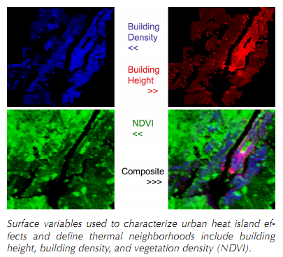 A city’s urban heat island can be subdivided into physically defined neighborhoods that respond differently to large scale environmental forcing. The observed bias from the modeled temperature would be similar throughout a thermal neighborhood, but vary between neighborhoods. The initial hypothesis is that average building height, building density, and vegetation density can be used to define thermal neighborhoods by applying cluster analysis to these physical variables plus the spatial location. To test if the neighborhood assignments are meaningful, a field campaign will measure temperatures throughout the urban heat island and see if these field measurements do indeed cluster inside each neighborhood.
After the thermal neighborhoods are established, records and ongoing data collection from an array of weather stations throughout the city may be used to monitor the temperature. Station data will be compared to the city wide urban neighborhood field campaign to assess biases. It is expected that other variables such as cloudiness, wind, and soil moisture will affect these biases. A response matrix containing all combinations of the predictive variables (predicted temperature, cloud cover, wind, moisture) will catalogue the temperature biases for each neighborhood depending on environmental conditions.
Investigators: Reza Khanbilvardi, Brian Vant-Hull, Mark Arend
CONTACT US
 > Email