Data Tools
New York State Building Footprints with Flood Analysis
Stakeholder: NYSERDA
The New York State Building Footprints with Flood Analysis project provides a flood assessment model with integrated coastal and riverine flood projections, storm and sea level rise scenarios, building footprints, critical infrastructure, and damage assessments. This tool covers all counties in New York State, excluding New York City. County-specific data is being published on an ongoing basis.
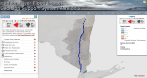
Hudson River Flood Impacts Decision Support System
Stakeholders: NYSERDA, local communities in the Hudson River Valley
The data, maps, and information in the Hudson River Flood Impact Decision Support System are provided to illustrate the scale of potential flooding in the Hudson River Valley under different sea level rise and storm scenarios. The information can help municipal and regional planners prepare for future floods.
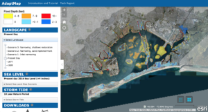
AdaptMap
Stakeholders: Wildlife Conservation Society, National Park Service, New York City Department of Environmental Protection
AdaptMap is an online mapping tool that demonstrates how sea level rise will worsen storm-driven flooding, such as the 100-year flood zone. It also enables users to select flood adaptation scenarios to see how they reduce flooding. Additionally, AdaptMap displays historic landscapes for the years 1609 and 1877 with associated historic flood zones.
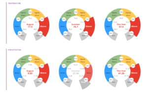
Climate Summary Gauges
Stakeholders: Northeast Regional Climate Center
The Northeast Regional Climate Center’s Climate Summary Gauges are based on daily data from the ThreadEx dataset developed by the NRCC. The long-term time series of each variable is sorted and divided into four segments, each containing one quarter of the total available data. These quarters correspond to categories from below normal to above normal climate conditions at stations throughout the Northeast.
Climate Vulnerability Decision Support Tools
Stakeholder(s): Community Based Organizations in the CCRUN Region
This spreadsheet is designed to assist organizations in the CCRUN region in identifying appropriate climate data sources and tools based on a variety of coastal and climate risk factors, including extreme weather, sea-level rise, and the social vulnerability of specific communities. Providing over 50 climate vulnerability risk assessment tools, including those listed above, across states, localities, and regions, this resource is intended to serve a diverse range of climate risk and vulnerability issues experienced in the Urban Northeast.
Rockaway Homeowner’s Guide to Preparing for Flooding
Stakeholder(s): Rockaway Initiative for Sustainability and Equity (RISE)
This guide contains a set of resources that can help a homeowner plan what they want to do to prepare their home for flooding and how they can make their plan happen. While a household can use the resources in this guide on their own, you may find it helpful to use this material as a starting point for conversations with others in your community both to help you understand the material in this guide and because it may be helpful to you to know what others in the community are planning to do as you consider your options.